Yesterday, May 8th, was warmer that we got all of last summer here in Island Pond, VT. The high was 87°, and last summers high was 85° on both July 1st and 2nd. The only nice part was very low dew points yesterday keeping the humidity levels down compared to last July. Fortunately for those of us that don’t like it quite that hot, temperatures dropped off fairly quick as soon as the sun started to set on the Northeast Kingdom. The low today was 46°. The current temperature at 12:45PM is 77°.
The forecast for the next several days looks to be wet with rain showers just about everyday. But, we do need the rain to help green things up, and help keep the fire danger down. Here’s a look at the upcoming weather for Island Pond as forecast by the NWS in Burlington. Don’t forget you can get the local forecast here on our website by clicking here.
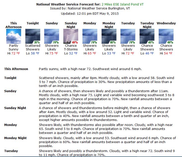
Forecast for Island Pond, VT from NWS in Burlington
Winter Weather Advisory Issued for 3/3/15
The NWS in Burlington, VT has issued a Winter Weather Advisory for our area from 6PM tonight through 7AM tomorrow morning. Unlike most of the storms this winter, it looks like this one will include some heavy wet snow and some mixed precipitation. Below is the statement issued by the NWS.
ORLEANS-ESSEX-LAMOILLE-CALEDONIA-WASHINGTON-EASTERN FRANKLIN-
EASTERN CHITTENDEN-EASTERN ADDISON-EASTERN RUTLAND-
INCLUDING THE CITIES OF…NEWPORT…ISLAND POND…JOHNSON…
STOWE…ST. JOHNSBURY…MONTPELIER…ENOSBURG FALLS…RICHFORD…
UNDERHILL…BRISTOL…RIPTON…EAST WALLINGFORD…KILLINGTON
312 AM EST TUE MAR 3 2015
…WINTER WEATHER ADVISORY IN EFFECT FROM 6 PM THIS EVENING TO
7 AM EST WEDNESDAY…
THE NATIONAL WEATHER SERVICE IN BURLINGTON HAS ISSUED A WINTER
WEATHER ADVISORY FOR MODERATE SNOW…WHICH IS IN EFFECT FROM 6 PM
THIS EVENING TO 7 AM EST WEDNESDAY.
* LOCATIONS…NORTH-CENTRAL AND NORTHEASTERN VERMONT…AND ALONG
THE SPINE OF THE GREEN MOUNTAINS.
* HAZARD TYPES…MODERATE SNOW.
* ACCUMULATIONS…3 TO 5 INCHES OF SNOW.
* MAXIMUM SNOWFALL RATE…UP TO 1 INCH PER HOUR…MAINLY THIS
EVENING THROUGH MIDNIGHT.
* TIMING…SNOW WILL DEVELOP ACROSS THE REGION DURING THE EARLY
EVENING HOURS…AND BECOME MODERATE AT TIMES THROUGH MIDNIGHT.
SNOW WILL TAPER OFF AFTER MIDNIGHT…WITH PERIODS OF FREEZING
DRIZZLE POSSIBLE DURING THE PRE-DAWN HOURS.
* IMPACTS…SLOW AND SLIPPERY TRAVEL CONDITIONS OVERNIGHT DUE TO
SNOW COVERED ROADWAYS AND LOW VISIBILITY.
* WINDS…SOUTH 5 TO 15 MPH WITH GUSTS UP TO 30 MPH.
* TEMPERATURES…STEADY IN THE LOW TO MID 20S.
* VISIBILITIES…AS LOW AS ONE HALF MILE AT TIMES…MAINLY BETWEEN
6 PM THIS EVENING AND 1 AM TONIGHT.
PRECAUTIONARY/PREPAREDNESS ACTIONS…
A WINTER WEATHER ADVISORY FOR SNOW MEANS THAT PERIODS OF SNOW
WILL CAUSE TRAVEL DIFFICULTIES. BE PREPARED FOR SNOW COVERED ROADS
AND LIMITED VISIBILITIES…AND USE CAUTION WHILE DRIVING.
PLEASE STAY TUNED TO NOAA WEATHER RADIO…YOUR LOCAL MEDIA…OR
GO TO WWW.WEATHER.GOV/BURLINGTON FOR FURTHER UPDATES ON THIS
WEATHER SITUATION.
More cold followed by Winter Storm Watch
Today was a chilly day in the Northeast Kingdom of Vermont. The high for the day, 26 degrees, occurred at 12AM and dropped off from there . The weather station displayed temps around 11-12 degrees this afternoon. The current temperature as I write this blog post is 5 degrees at 6PM here in Island Pond, VT. The National Weather Service forecast is calling for a low tomorrow morning of -7F. The forecast for tomorrow, Monday December 8th is calling for mostly sunny skies ahead of a storm system that will be moving in on Tuesday morning.
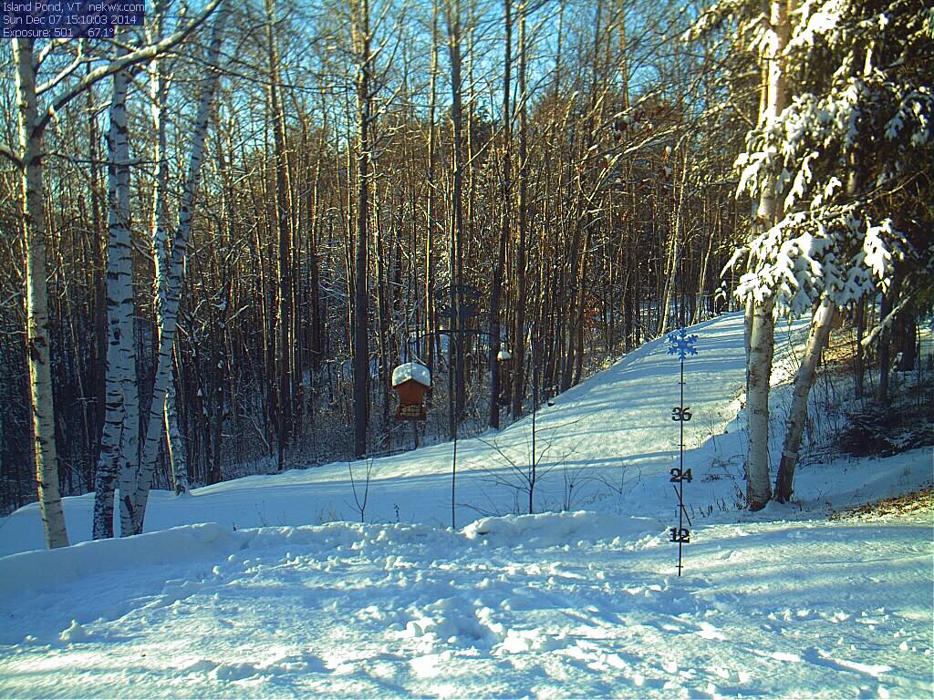
The calm before the storm. Today was a blue sky day as seen on our Island Pond, VT webcam. 12/7/14
Below is the text of the Winter Storm Watch issued by the NWS in Burlington, VT.
...WINTER STORM WATCH IN EFFECT FROM TUESDAY MORNING THROUGH
WEDNESDAY AFTERNOON...

THE NATIONAL WEATHER SERVICE IN BURLINGTON HAS ISSUED A WINTER
STORM WATCH...WHICH IS IN EFFECT FROM TUESDAY MORNING THROUGH
WEDNESDAY AFTERNOON.

* LOCATIONS...CENTRAL AND NORTHERN VERMONT AND NORTHERN NEW YORK
  EXCEPT THE ST. LAWRENCE VALLEY.

* HAZARD TYPES...HEAVY WET SNOW...SLEET...AND FREEZING RAIN.

* ACCUMULATIONS...POTENTIAL FOR 6 TO 12 INCHES OF SNOW WITH
  LOCALLY HIGHER AMOUNTS IN THE SOUTH CENTRAL GREEN MOUNTAINS.
  THERE MAY ALSO BE UP TO A QUARTER OF AN INCH OF ICE IN EASTERN
  VERMONT.

* MAXIMUM SNOWFALL RATE...UP TO 2 INCHES PER HOUR...MAINLY TUESDAY
  AFTERNOON THROUGH TUESDAY EVENING.

* TIMING...LIGHT SNOW WILL BEGIN TUESDAY BECOMING HEAVY TUESDAY
  AFTERNOON AND EVENING AND WILL MIX WITH SLEET...FREEZING
  RAIN...AND RAIN AT TIMES ESPECIALLY IN VERMONT TUESDAY NIGHT AND
  WEDNESDAY.

* IMPACTS...HAZARDOUS DRIVING CONDITIONS ESPECIALLY FOR THE
  TUESDAY EVENING AND WEDNESDAY MORNING COMMUTES. THERE MAY BE
  SOME POWER OUTAGES DUE TO THE HEAVY WET SNOW AND SOME ICING.

* WINDS...NORTHEAST 10 TO 20 MPH WITH GUSTS UP TO 25 MPH.

* TEMPERATURES...HIGHS IN THE LOWER 30S. LOWS IN THE LOWER 20S.

* VISIBILITIES...REDUCED TO A QUARTER OF A MILE AT TIMES.

PRECAUTIONARY/PREPAREDNESS ACTIONS...

A WINTER STORM WATCH MEANS THERE IS A POTENTIAL FOR SIGNIFICANT
SNOW...SLEET...OR ICE ACCUMULATIONS THAT MAY IMPACT TRAVEL.
CONTINUE TO MONITOR THE LATEST FORECASTS.

PLEASE STAY TUNED TO NOAA WEATHER RADIO...YOUR LOCAL MEDIA...OR
GO TO WWW.WEATHER.GOV/BURLINGTON FOR FURTHER UPDATES ON THIS
WEATHER SITUATION.