Tag Archives: 2014

November snow in the NEK

It has been snowing in Island Pond most of the day., but with the temperature just above freezing it melted as soon as it hit the ground.  Around 4PM the temperature dropped below 32° and it started to stick to the car and grassy surfaces here in IP.  In the higher elevations of the Northeast Kingdom it remained below freezing all day. In those places a few inches of snow did accumulate.

I did setup the snow stake in front of the webcam this afternoon just in case we get more than expected overnight.

island pond webcam

Snow stake is setup on the Island Pond, VT webcam

Snow did accumulate in some of the higer elevations of the NEK today. One such place was at a friends house in Walden, VT. Here’s an image from his webcam from this afternoon.

Coles Pond webcam 11/7/14

Coles Pond webcam 11/7/14

Winter Weather Advisory posted for 11/7/14

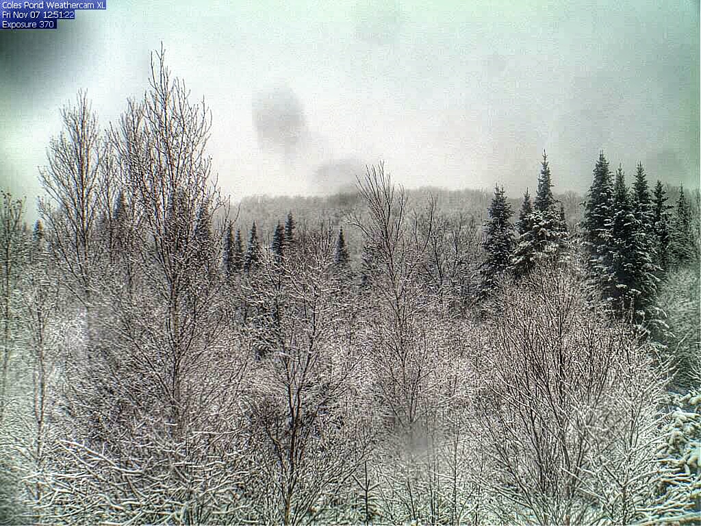
The National Weather Service in Burlington,  VT has issued a Winter Weather Advisory for the Northeast Kingdom. I guess I better get the snow stake setup in the webcam view in case we do get some accumulating snow. Below is the Advisory text.

WINTER WEATHER ADVISORY IN EFFECT FROM 1 AM TO 7 PM EST FRIDAY…

THE NATIONAL WEATHER SERVICE IN BURLINGTON HAS ISSUED A WINTER WEATHER ADVISORY FOR SNOW…WHICH IS IN EFFECT FROM 1 AM TO 7 PM EST FRIDAY.

* LOCATIONS…GREEN MOUNTAINS AND NORTH CENTRAL AND NORTHEAST VERMONT.

* HAZARD TYPES…HEAVY WET SNOW. * ACCUMULATIONS…2 TO 5 INCHES OF HEAVY WET SNOW WITH THE HIGHEST SNOWFALL TOTALS ABOVE 1500 FEET.

* MAXIMUM SNOWFALL RATE…UP TO 1 INCH PER HOUR…MAINLY EARLY FRIDAY MORNING.

* TIMING…RAIN WILL TRANSITION TO SNOW OVER LOWER ELEVATIONS BY 4 AM AND BE HEAVIEST THROUGH THE EARLY MORNING. LIGHT SNOW WILL CONTINUE TOMORROW TAPERING OFF INTO THE EVENING.

* IMPACTS…UNTREATED ROAD SURFACES MAY BECOME SLUSHY ESPECIALLY AT HIGHER ELEVATIONS. TEMPERATURES WILL DROP BELOW FREEZING IN THE EARLY EVENING WHICH WILL CAUSE ANY PRECIPITATION STILL ON THE GROUND TO FREEZE RESULTING IN ICY ROADS.

* WINDS…NORTHWEST 5 TO 15 MPH WITH GUSTS UP TO 25 MPH.

* TEMPERATURES…LOWS IN THE MID 30S. HIGHS IN THE MID 30S.

* VISIBILITIES…VISIBILITIES COULD DROP TO 1/2 MILE AT TIMES.

PRECAUTIONARY/PREPAREDNESS ACTIONS… WITH THE STRONG ELEVATIONAL DEPENDENCE OF THIS STORM…WATCH FOR RAPIDLY CHANGING ROAD CONDITIONS IF TRAVELING IN MOUNTAINOUS TERRAIN. PLEASE STAY TUNED TO NOAA WEATHER RADIO…YOUR LOCAL MEDIA…OR GO TO WWW.WEATHER.GOV/BURLINGTON FOR FURTHER UPDATES ON THIS WEATHER SITUATION.


Cloudy days, snow to kick off November???

I am starting to get tired of all of this dreary weather that we have been having lately.  Although it hasn’t really rained much, cloudy days have dominated the weather for most of the week, and are forecast for the rest of the week here in the Northeast Kingdom of Vermont.

There is a chance of snow coming to Island Pond and the NEK with a system that will be moving through this weekend.  It’s a little early to say how much snow that may fall, but it does look like we will see the coldest air of the season after the storm passes through. I guess it is about time to dig out the snow stake.

NEK Vt webcam Island Pond

Clouds dominate the weather in Island Pond, VT