Tag Archives: wx

Late April Update

It’s been way to long since my last blog post here on nekwx.com. I’ll try to do a better job updating this page going forward.

Over the past month we have gone from having 24″ of snow on the snow stake to zero snow with the exception of a little snow on the north side of the buildings from where the roofs slid off. There were times over the past several weeks I wondered if spring was ever going to arrive in the Northeast Kingdom of Vermont. I guess the good thing about it was the cooler weather helped keep the rivers and streams from overflowing like often happens when we have a rapid warm up.

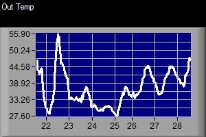
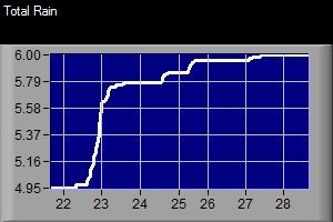
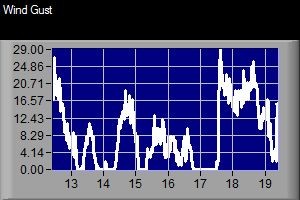
Over the past week it has been mostly cloudy and cool with both rain and snow showers falling here in Island Pond. Here are a couple of graphs showing the weather data over the past 7 days.


Temps over the past week in Island Pond, VT

Temps over the past week in Island Pond, VT

Rain over the past 7 day in Island Pond, VT

Rain over the past 7 day in Island Pond, VT

Wind over the past 7 days in Island Pond,VT

Wind over the past 7 days in Island Pond,VT

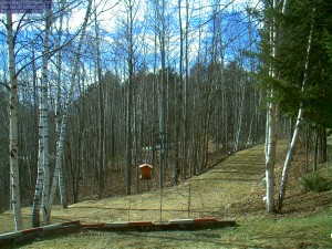
I’ll end this post with a recent image from the Island Pond Webcam

It's nice to see the sun shinning today on the Island Pond webcam!

It’s nice to see the sun shinning today on the Island Pond webcam!

40° Plus Past 2 Days in Island Pond, VT!!!

It has really felt good to see temperatures warm in to the 40’s for both Tuesday and Wednesday! Tuesday was the warmest with a high of 48° here in Island Pond, VT. Today was a little windier and cooler with the high reaching 42°.  Even the overnight low didn’t go below freezing on Wednesday morning,  36° was the morning low.

Unfortunately cooler weather will return as a cold front moves through the Northeast Kingdom of Vermont this evening. The front will bring with it a chance of flurries or light snow. Not much accumulation is expected with the front but some areas of the NEK could see 1-2 inches of new snow. The next storm should arrive over the weekend and as of right now it looks like a mix of snow and rain.

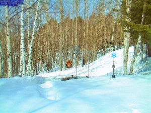
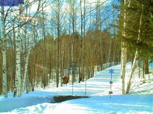
Here is a photo from the Island Pond Webcam on Tuesday followed by an image from the cam on Wednesday. As you can see, we’ve lost quite a bit of snow during the warmup.

Island Pond, VT Webcam

Snow depth in Island Pond, VT on Tuesday March 10, 2015

Island Pond, VT webcam

Snow depth in Island Pond, VT on Wednesday March 11, 2013

Winter Weather Advisory Issued for 3/3/15

The NWS in Burlington, VT has issued a Winter Weather Advisory for our area from 6PM tonight through 7AM tomorrow morning. Unlike most of the storms this winter, it looks like this one will include some heavy wet snow and some mixed precipitation. Below is the statement issued by the NWS.

ORLEANS-ESSEX-LAMOILLE-CALEDONIA-WASHINGTON-EASTERN FRANKLIN-
EASTERN CHITTENDEN-EASTERN ADDISON-EASTERN RUTLAND-
INCLUDING THE CITIES OF…NEWPORT…ISLAND POND…JOHNSON…
STOWE…ST. JOHNSBURY…MONTPELIER…ENOSBURG FALLS…RICHFORD…
UNDERHILL…BRISTOL…RIPTON…EAST WALLINGFORD…KILLINGTON
312 AM EST TUE MAR 3 2015

…WINTER WEATHER ADVISORY IN EFFECT FROM 6 PM THIS EVENING TO
7 AM EST WEDNESDAY…

THE NATIONAL WEATHER SERVICE IN BURLINGTON HAS ISSUED A WINTER
WEATHER ADVISORY FOR MODERATE SNOW…WHICH IS IN EFFECT FROM 6 PM
THIS EVENING TO 7 AM EST WEDNESDAY.

* LOCATIONS…NORTH-CENTRAL AND NORTHEASTERN VERMONT…AND ALONG
THE SPINE OF THE GREEN MOUNTAINS.

* HAZARD TYPES…MODERATE SNOW.

* ACCUMULATIONS…3 TO 5 INCHES OF SNOW.

* MAXIMUM SNOWFALL RATE…UP TO 1 INCH PER HOUR…MAINLY THIS
EVENING THROUGH MIDNIGHT.

* TIMING…SNOW WILL DEVELOP ACROSS THE REGION DURING THE EARLY
EVENING HOURS…AND BECOME MODERATE AT TIMES THROUGH MIDNIGHT.
SNOW WILL TAPER OFF AFTER MIDNIGHT…WITH PERIODS OF FREEZING
DRIZZLE POSSIBLE DURING THE PRE-DAWN HOURS.

* IMPACTS…SLOW AND SLIPPERY TRAVEL CONDITIONS OVERNIGHT DUE TO
SNOW COVERED ROADWAYS AND LOW VISIBILITY.

* WINDS…SOUTH 5 TO 15 MPH WITH GUSTS UP TO 30 MPH.

* TEMPERATURES…STEADY IN THE LOW TO MID 20S.

* VISIBILITIES…AS LOW AS ONE HALF MILE AT TIMES…MAINLY BETWEEN
6 PM THIS EVENING AND 1 AM TONIGHT.

PRECAUTIONARY/PREPAREDNESS ACTIONS…

A WINTER WEATHER ADVISORY FOR SNOW MEANS THAT PERIODS OF SNOW
WILL CAUSE TRAVEL DIFFICULTIES. BE PREPARED FOR SNOW COVERED ROADS
AND LIMITED VISIBILITIES…AND USE CAUTION WHILE DRIVING.

PLEASE STAY TUNED TO NOAA WEATHER RADIO…YOUR LOCAL MEDIA…OR
GO TO WWW.WEATHER.GOV/BURLINGTON FOR FURTHER UPDATES ON THIS
WEATHER SITUATION.