Tag Archives: wx

First frost of the season

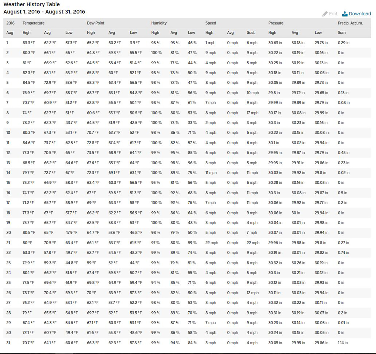
It’s been chilly here in  northern VT the past couple of mornings. Yesterday, September 15, 2016, my weather station recorded a low temperature of 40°F. This morning was even cooler and produced the first frost of the season in many locations in the Northeast Kingdom of VT and Northern NH. The low temperature here in Island Pond was a chilly 33.8°F.

vermont frost

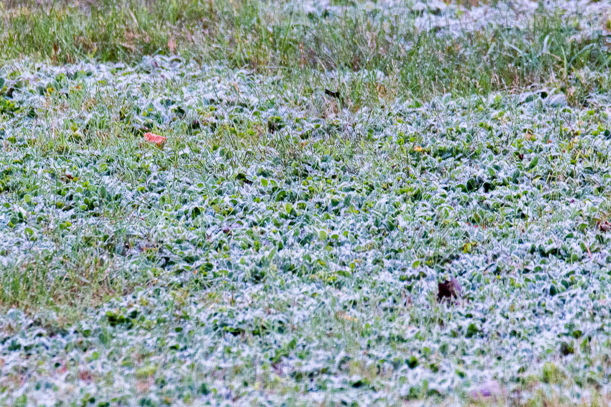
First frost of the season in Island Pond, VT.


Here’s a map from the National Weather Servive in Burlington, VT showing the recorded low temperature for Friday September 16, 2016

vt low temperature map

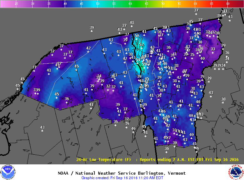
Low temperatures for 9/16/19

The color overnight temperatures should help move the 2016 Fall Foliage along here in Vermont.

Fall Foliage 2016 NEK VT

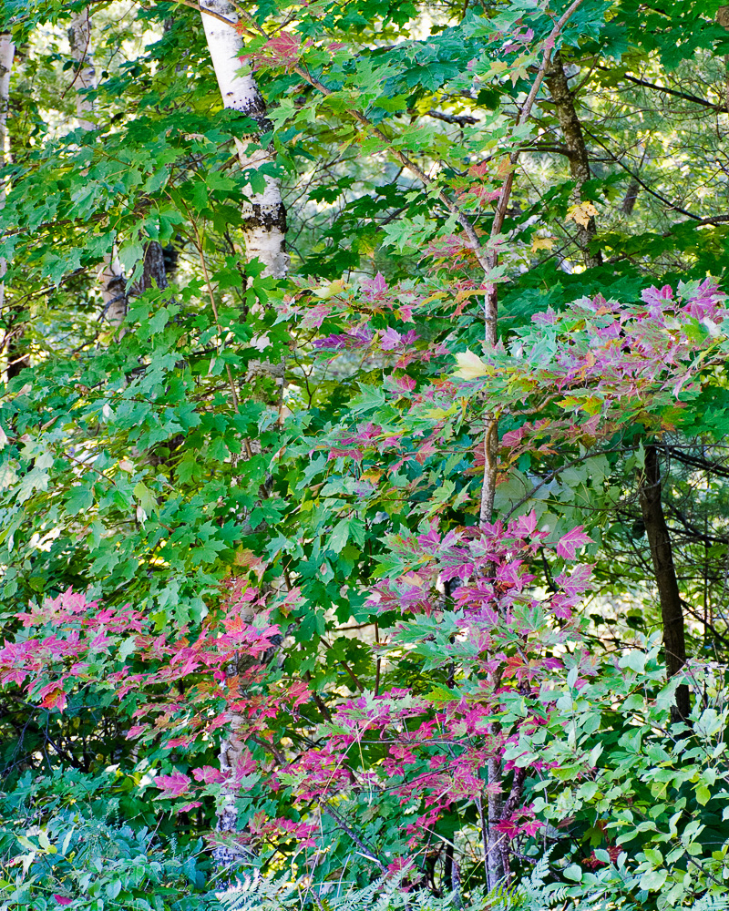
Splash of color on a small maple in my back yard in Island Pond, VT (photo taken 9/16/16)

August 2016 Weather Summary For Island Pond, VT

Now that August is in the books I thought I would put together a weather summary from the data collected with my weather station here in Island Pond, VT.

The high temperature for the month was 84.6 °F on the 11th. The low for August was 43.7 °F on the 9th. The station recorded 4.26″ of rain for the month.

Here’s the daily records for Island Pond, VT.

island pond weather

Daily weather data for Island Pond, VT

Winter Storm Warning For NEK 12/29/15

Winter Storm Warning

URGENT - WINTER WEATHER MESSAGE
NATIONAL WEATHER SERVICE BURLINGTON VT
336 PM EST MON DEC 28 2015

VTZ003-004-006-007-291000-
/O.UPG.KBTV.WW.Y.0015.151229T0500Z-151230T0000Z/
/O.NEW.KBTV.WS.W.0006.151229T0500Z-151230T0000Z/
ORLEANS-ESSEX-LAMOILLE-CALEDONIA-
INCLUDING THE CITIES OF...NEWPORT...ISLAND POND...JOHNSON...
STOWE...ST. JOHNSBURY
336 PM EST MON DEC 28 2015

...WINTER STORM WARNING IN EFFECT FROM MIDNIGHT TONIGHT TO 7 PM
EST TUESDAY...

THE NATIONAL WEATHER SERVICE IN BURLINGTON HAS ISSUED A WINTER
STORM WARNING FOR SNOW AND MIXED PRECIPITATION...WHICH IS IN
EFFECT FROM MIDNIGHT TONIGHT TO 7 PM EST TUESDAY. THE WINTER
WEATHER ADVISORY IS NO LONGER IN EFFECT.

* LOCATIONS...NORTHEASTERN VERMONT.

* HAZARD TYPES...MODERATE TO HEAVY SNOW EARLY TUESDAY MORNING
  WITH SLEET AND FREEZING DRIZZLE CONTINUING TUESDAY AFTERNOON.

* ACCUMULATIONS...SNOW ACCUMULATION OF 4 TO 8 INCHES...ALONG WITH
  UP TO A TENTH OF AN INCH OF ICE.

* MAXIMUM SNOWFALL RATE...AROUND 1 INCH PER HOUR...MAINLY EARLY
  TUESDAY MORNING.

* TIMING...SNOW WILL OVERSPREAD THE REGION IN THE PRE-DAWN HOURS
  OF TUESDAY MORNING...AND BECOME HEAVY AT TIMES BETWEEN 4 AM
  AND 10 AM. THE SNOW WILL THEN CHANGE OVER TO A MIX OF SLEET
  AND FREEZING DRIZZLE BY NOON ON TUESDAY.

* IMPACTS...SNOW WILL CAUSE VERY HAZARDOUS TRAVEL FOR THE TUESDAY
  MORNING COMMUTE. ROADS WILL BECOME SNOW-COVERED AND SLIPPERY.

* WINDS...SOUTHEAST 5 TO 15 MPH WITH GUSTS UP TO 25 MPH.

* TEMPERATURES...LOWS AROUND 10 ABOVE. HIGHS IN THE MID 20S.

* VISIBILITIES...A HALF MILE OR LESS IN MODERATE TO HEAVY SNOW.

PRECAUTIONARY/PREPAREDNESS ACTIONS...

A WINTER STORM WARNING MEANS SIGNIFICANT AMOUNTS OF
SNOW...SLEET...AND ICE ARE EXPECTED OR OCCURRING. THIS WILL MAKE
TRAVEL VERY HAZARDOUS.

PLEASE STAY TUNED TO NOAA WEATHER RADIO...YOUR LOCAL MEDIA...OR
GO TO WWW.WEATHER.GOV/BURLINGTON FOR FURTHER UPDATES ON THIS
WEATHER SITUATION.