Tag Archives: Northeast Kingdom

Where did winter go?

It’s hard to believe winter has come and gone without registering 12″ of snow on the stake here in Island Pond, VT. I kept holding out hope all season that we would get a good dumping of the white stuff, but it never did happen. This had to be very hard on the businesses throughout the Northeast Kingdom that rely on skiers and snowmobiliers to frequent their restaurants and stores. Hopefully we have a beautiful Spring and Summer season that helps make up for such a dismal Winter.

Here’s a video that was shot last weekend that shows just how bad the snow season was here in the NEK. About the only snow to be found is man made with the exception of the very top of Burke Mountain.

 

Winter Storm Warning For NEK 12/29/15

Winter Storm Warning

URGENT - WINTER WEATHER MESSAGE
NATIONAL WEATHER SERVICE BURLINGTON VT
336 PM EST MON DEC 28 2015

VTZ003-004-006-007-291000-
/O.UPG.KBTV.WW.Y.0015.151229T0500Z-151230T0000Z/
/O.NEW.KBTV.WS.W.0006.151229T0500Z-151230T0000Z/
ORLEANS-ESSEX-LAMOILLE-CALEDONIA-
INCLUDING THE CITIES OF...NEWPORT...ISLAND POND...JOHNSON...
STOWE...ST. JOHNSBURY
336 PM EST MON DEC 28 2015

...WINTER STORM WARNING IN EFFECT FROM MIDNIGHT TONIGHT TO 7 PM
EST TUESDAY...

THE NATIONAL WEATHER SERVICE IN BURLINGTON HAS ISSUED A WINTER
STORM WARNING FOR SNOW AND MIXED PRECIPITATION...WHICH IS IN
EFFECT FROM MIDNIGHT TONIGHT TO 7 PM EST TUESDAY. THE WINTER
WEATHER ADVISORY IS NO LONGER IN EFFECT.

* LOCATIONS...NORTHEASTERN VERMONT.

* HAZARD TYPES...MODERATE TO HEAVY SNOW EARLY TUESDAY MORNING
  WITH SLEET AND FREEZING DRIZZLE CONTINUING TUESDAY AFTERNOON.

* ACCUMULATIONS...SNOW ACCUMULATION OF 4 TO 8 INCHES...ALONG WITH
  UP TO A TENTH OF AN INCH OF ICE.

* MAXIMUM SNOWFALL RATE...AROUND 1 INCH PER HOUR...MAINLY EARLY
  TUESDAY MORNING.

* TIMING...SNOW WILL OVERSPREAD THE REGION IN THE PRE-DAWN HOURS
  OF TUESDAY MORNING...AND BECOME HEAVY AT TIMES BETWEEN 4 AM
  AND 10 AM. THE SNOW WILL THEN CHANGE OVER TO A MIX OF SLEET
  AND FREEZING DRIZZLE BY NOON ON TUESDAY.

* IMPACTS...SNOW WILL CAUSE VERY HAZARDOUS TRAVEL FOR THE TUESDAY
  MORNING COMMUTE. ROADS WILL BECOME SNOW-COVERED AND SLIPPERY.

* WINDS...SOUTHEAST 5 TO 15 MPH WITH GUSTS UP TO 25 MPH.

* TEMPERATURES...LOWS AROUND 10 ABOVE. HIGHS IN THE MID 20S.

* VISIBILITIES...A HALF MILE OR LESS IN MODERATE TO HEAVY SNOW.

PRECAUTIONARY/PREPAREDNESS ACTIONS...

A WINTER STORM WARNING MEANS SIGNIFICANT AMOUNTS OF
SNOW...SLEET...AND ICE ARE EXPECTED OR OCCURRING. THIS WILL MAKE
TRAVEL VERY HAZARDOUS.

PLEASE STAY TUNED TO NOAA WEATHER RADIO...YOUR LOCAL MEDIA...OR
GO TO WWW.WEATHER.GOV/BURLINGTON FOR FURTHER UPDATES ON THIS
WEATHER SITUATION.

Warm in the NEK

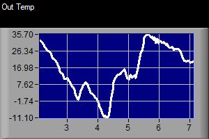
Temperatures have been unseasonably warm around here for the past few months. We have had a few shots of cold air, but temperatures have been above to well above normal. Yesterday, December 11, 2015, we had a high of  51.6°F.

Temperatures in Island Pond, VT 12/6/15- 12/12/15

Temperatures in Island Pond, VT 12/6/15- 12/12/15

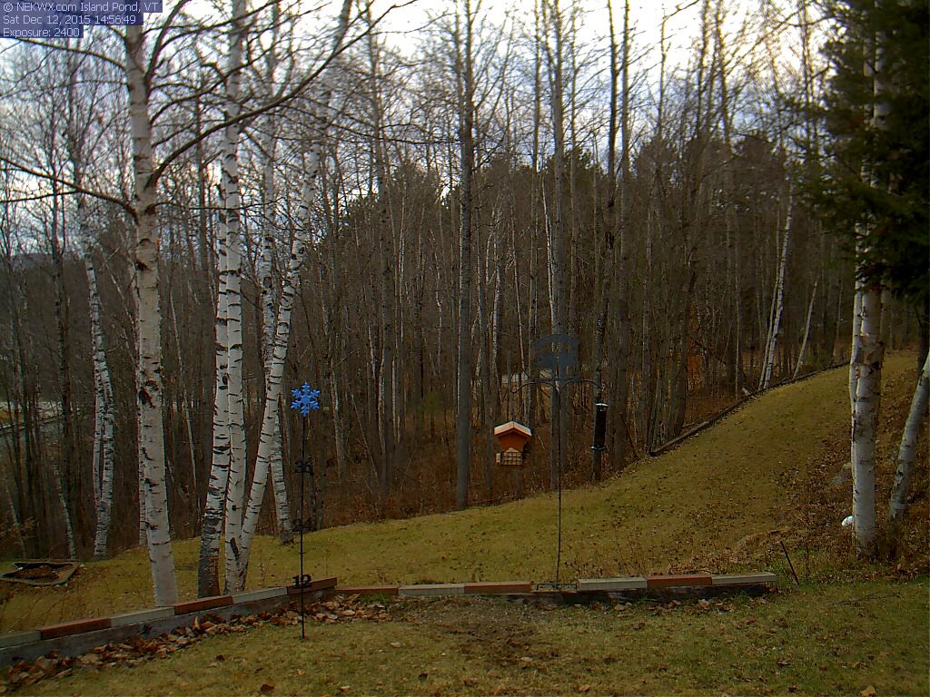
Unfortunately for snow lovers these warm temperatures have melted most of the snow that fell at the beginning of the month. There isn’t any snow left here in Island Pond. However as of this morning there was still an inch or two left at elevations above 1500′ in parts of the Northeast Kingdom.

Island Pond Webcam

No snow on the webcam in Island Pond, VT

It’s starting to look like we may be in for a brown Christmas this year if we don’t see a change in our weather pattern over the next week or so.